
Please, click on any selected image to view it Large or Largest:

Picture - GOOGLE
Rara National Park is located in
North-West Nepal about 371
Km. air distance from kathmandu. The
park headquarters is about 32 Km. north to Jumla. Most of the park
including Lake Rara lies in Mugu District, with a small area in Jumla
District of Karnali Zone. This is the smallest park in Nepal ( 106
sq. km. ) with the country's biggest lake ( 10.8 sq. km. ) at an elevation
of 2990 m.
The lake is oval-shaped with an
east-west axis, and has a maximum length of 5 km. and a width of 3 km. The
maximum depth of the lake is 167m. The park was gazetted in 1976 to
conserve the unique beauty of Lake Rara and to protect a
representative sample of flora and fauna of the Humla-Jumla region.
Summer is pleasant, however, the winter
brings cold temperatures and heavy snowfall ( up to one meter ). The best time
to visit is October to December or March to May. The winter is quite severe with
ground frost occuring from October.
Taking a flight from Nepalgunj or
Kathmandu to Jumla or Kolti
(Bajura) is the best way of approaching
the lake. From Jumla,
it takes about three and a half days on
foot to reach Rara Lake.
From Kolti, it takes normally two days.
- Park Headquarters, Hutu, Rara
0r
Department of National Parks and Wildlife Conservation,
Babar Mahal, Kathmandu
Ph No.: 4220850, 4220912, 4227926
Fax: 97714227675, 97714410073
If there's a heaven on earth, this is the Rara Lake !


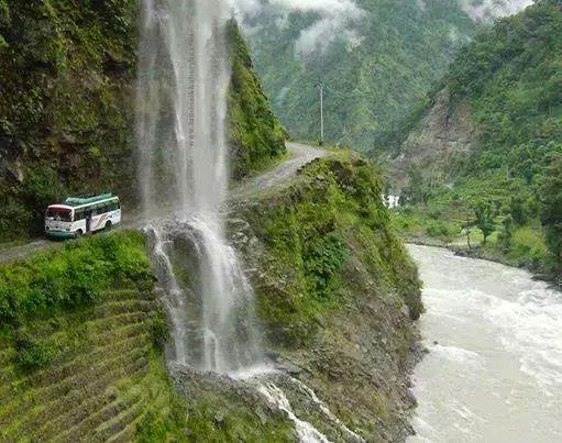
 Bungee jumping or swinging over the Bhote Kosi has been described as the ‘ultimate experience’. The valley is narrow with steep hillsides towering over 2,000 metres (6,600 ft) from the river.The source of the Rongshar Tsangpo or Bhote Kosi lies in the mountains to the east of the Kathmandu-Lhasa Highway in Tibet. Nepal's first bungee jumping site is situated at Last Resort / Friendship bridge, 160 metres (520 ft) above a gorge with the river raging below. It is 12 kilometres (7.5 mi) from the Nepal-China border.[4][5][6] Bungee jumping at the Last Resort is one of the longest in the world. It is higher than the highest bungee in the New Zealand.[4]After leaping from the bridge platform, the bungee jumper has a free fall towards the river before the swing lines take up the tension and he enters a large, semicircular arc of about 240 metres (790 ft).[7] When it opened in 1999, the Last Resort was amongst the highest suspension footbridges in the world.
Swiss designed, especially for bungee jumping with a 4x safety factor, the bridge will hold 4.5 tonnes. Over 6,000 metres (20,000 ft) of steel wire was used to build the longest suspension bridge in Nepal.
Actual costs need to be checked with the service provider, but just to give a basic idea about costs: the swing or bungee costs 80 US dollars, including lunch and return transport from Kathmandu. Extra jumps cost 25 dollars.(Nepalese are entitled to 30% discount.) A two-day bungee and rafting package with overnight accommodation, meals and transport costs 130 dollars.[4] It is around 3 hours by road from Kathmandu. The Bhote Kosi flows along the Arniko Rajmarg.
The bridge site also encompasses hiking, rafting, kayaking and mountain biking as well as overnight stays in a tent.
The Bhote Kosi is used for both rafting and kayaking.
The rapids here are class IV- V at high flow, and III at lower levels.
The river is steep and continuous with one rapid leading into another. Bhote Koshi river is located in Nepal, about 70 km (44 mi) east of Kathmandu.
- Wikipedia, the free encyclopedia
Bhote Kosi Bridge was designed by one of New Zealand's leading bungee consultants, and is operated by some of the most experienced jump masters in the business.


 Pictures - Google


 Dhulikhel lies along the B.P. Highwayand Arniko Highway. Arniko Highway connects Kathmandu, Nepal's capital city with Tibet's border town of Kodari. Dhulikhel is located at the Eastern rim of Kathmandu Valley, south of the Himalayas at 1550mabove sea level and is situated 30 km southeast of Kathmandu and 74 km southwest of Kodari. The people in the village are Newars,Brahmin, Chhettri, Tamang and Dalit. Drinking water in Dhulikhel is one of the best water in Nepal. It was made with the Help of the GermanNGO, German Technical Cooperation.
Dhulikhel has for many centuries been an important trading centre on the ancient commercial route linking Nepal to Tibet. Since time immemorial, people of Nepal travel to Tibet to bring home salt and gold. Likewise, the Tibetans every year with their flocks of sheep enter intoNepal during Dashain, the greatest Hindu festival. They purchased chilies and other daily necessities in Nepal and return to their homeland. In those days, a whole day walk from Kathmandu to Dhulikhel was comfortable for Tibet trippers with easily available of food and water at Dhulikhel at the evening for overnight stay. Even now, a bird's eye view from the resorts at Dhulikhel to the landscapes; highway to Tibet and horizons far to the Tibetan borders, clearly exhibits Dhulikhel as the gateway of Tibet. After adjoining with Tibet by motorable road in 1965, Dhulikhel got a face lift and developed as a tourist destination both for Tibet trippers and tourists. Dhulikhel is an ideal station to stop for overnight stay while going to Tibet and coming back to Kathmandu.
The Mountains - A Tourist Paradise: The spectacular snowfed mountains seen from Dhuklikhel must be one of the finest panoramic views in the world. When a blue haze covers the lower portion of the mountains, they seem to be floating in the air. With the snowy mountains on the backdrop, Dhulikhel is a stage of immense beauty and a paradise for nature lovers. Green inviting hills of which still virgin and some turned into beautifully carved agricultural terraces cater to the beholders' pleasure.
- Wikipedia, the free encyclopedia
 Picture - Sanjeev Kumar Shrestha / http://www.pernica.biz
 Picture - panautimun.gov.np
 Panauti Jatra ( festival ) / Photo - panautimun.gov.np
 Picture - Google / Makar Mela
Makar Mela is the biggest mela (a special religious festival ) of Nepal. It was celebrated in month of Magh 2066 B.S (Jan 15, 2010 - Feb 12, 2010). This mela is celebrated once a 12 year according to solar system of calendar when sun enters from KUMBHA to MAKAR rashi.
Oh ! Next Makar Mela will be on 2078 B.S. (2022 A.D). So long to wait....
It is believed that during this mela, taking the holy bath in Triveni Ghat ( Rudrawati,Punyamata,Lilawati(Roshi) -
trio of three rivers )will wash all the sins and cure some skin diseases. It is also belived that after death ones soul rest in peace in Kailash Parwat. So large number of pilgrims gather in triveni Ghat of Panauti from all over the Nepal and some parts of India as well.
There are two small holes in front of Bramayani idol in Bramayani Temple, triveni ghat, Panauti. This hole is void all the time but filled with the water only during Makar Mela only. The reason behind it is that river Rudrawati is flowing below the Bramayni temple and it meets with Punyamata River and Lilawati(Roshi) river to form Triveni (trio of three river) and the water level of Rudrawati rises once every 12 years.
- http://makarmela.com
 Photo - contest.thesca.org / Women harvesting rice
 Panauti, a small town located 32 km Southeast of Kathmandu, found in the central regions of Nepal. Panauti is a very historical city found in Nepal, as it was originally a small state given by King Bhupatindra Malla as a dowry to his sister. This small town has a population of under 30,000 people and a few prominent icons, such as the Indreswor temple and Durbar square found in the town center. At the end of the 13th Century, Panauti was finally integrated into the unified kingdom of Nepal, along with Kathmandu, Patan, and Bakthapur, which are all former capital cities of the Kathmandu valley. Panauti consists of a variety of Buddhist and Hindu religious monuments, and is considered to be one of the area’s most important medieval sites.
- http://makarmela.com


 Photo - mlphotographys.blogspot.com / Godavari


http://www.mcnepal.com/newsite/about.php
 Photo - visitlalitpur.blogspot.com / inside Botanical Garden, Godavari, Nepal
 Photo - Google
The main bathing, Sidheshower Mahadev Kunda is inside the door where the Bara Barse Godawari Mela held. It is the main spot of Bara Barse Godawari Mela where Millions of devotees swarm there to take the holy bath.

Picture - Wikipedia, the free
encyclopedia / Kakani, Nepal
Kakani is a settlement in the Nuwakot District of the Bagmati Zone in central Nepal. As one of the most accessible settlements from Kathmandu over 2000 meters. There is an unusually perfect blending of the imposing mountain scenery with the more sylvan environment of the lower valleys.
Rhododendrons growing wild on the mountain slopes begin to bloom in late winter and stay in bloom for several months, giving the village even more charm.
Article The book – Experience it in Nepal ( Nepal Tourism Board )
 Picture - Wikipedia, the free
encyclopedia
Picture - Wikipedia, the free
encyclopedia
This memorial park in Kakani, Nepal is dedicated to the memory of those killed in 1992 crash of Thai Airways International Flight 311.


 Picture - Wikipedia, the free encyclopedia
Gurkhas bungalow in Kakani


 vertical fall and sundarijal Bazar / A beautiful Sundarijal waterfall
Pictures - Google
 A beautiful pond in Sundarijal

If there's a heaven on earth, this is the Rara Lake !

Tilicho Lake, Manang, Nepal ( Picture - Google )

On the Way to Tilicho Lake ( Pictures - Kanchan K. C. )
Thorangla Pass, Panch Aaule Jharna ( water falls ) etc.,
great pleasant places.


Swiss designed, especially for bungee jumping with a 4x safety factor, the bridge will hold 4.5 tonnes. Over 6,000 metres (20,000 ft) of steel wire was used to build the longest suspension bridge in Nepal.
Actual costs need to be checked with the service provider, but just to give a basic idea about costs: the swing or bungee costs 80 US dollars, including lunch and return transport from Kathmandu. Extra jumps cost 25 dollars.(Nepalese are entitled to 30% discount.) A two-day bungee and rafting package with overnight accommodation, meals and transport costs 130 dollars.[4] It is around 3 hours by road from Kathmandu. The Bhote Kosi flows along the Arniko Rajmarg.
The bridge site also encompasses hiking, rafting, kayaking and mountain biking as well as overnight stays in a tent.
The Bhote Kosi is used for both rafting and kayaking.
The rapids here are class IV- V at high flow, and III at lower levels.
The river is steep and continuous with one rapid leading into another. Bhote Koshi river is located in Nepal, about 70 km (44 mi) east of Kathmandu.
- Wikipedia, the free encyclopedia
Bhote Kosi Bridge was designed by one of New Zealand's leading bungee consultants, and is operated by some of the most experienced jump masters in the business.


 Pictures - Google |
Nagarkot is a village and Village Development Committee located
32 km. east of Kathmandu, Nepal in Bhaktapur
District in the Bagmati Zone.
At the time of the 1991 Nepal census it
had a population of 3,504 and had 655 houses in it. At an elevation of 2,195 meters, it is
considered one of the most scenic spots in Bhaktapur
District. It is renowned for its sunrise view of the Himalaya including Mount Everest as
well as other snow-capped peaks of the Himalayan range of
eastern Nepal when the weather is clear.
Nagarkot also offers a panoramic view of the
Kathmandu Valley.
Nagarkot
is an international tourist destination with spectacular views of the whole
Langtang range, sunrise on the mountains and sunset views.
- Wikipedia, the free encyclopedia
  |


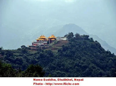
Views of holy, peaceful & beautiful Namo Buddha

Inside Namo Buddha
Pictures : Google

Dhulikhel has for many centuries been an important trading centre on the ancient commercial route linking Nepal to Tibet. Since time immemorial, people of Nepal travel to Tibet to bring home salt and gold. Likewise, the Tibetans every year with their flocks of sheep enter intoNepal during Dashain, the greatest Hindu festival. They purchased chilies and other daily necessities in Nepal and return to their homeland. In those days, a whole day walk from Kathmandu to Dhulikhel was comfortable for Tibet trippers with easily available of food and water at Dhulikhel at the evening for overnight stay. Even now, a bird's eye view from the resorts at Dhulikhel to the landscapes; highway to Tibet and horizons far to the Tibetan borders, clearly exhibits Dhulikhel as the gateway of Tibet. After adjoining with Tibet by motorable road in 1965, Dhulikhel got a face lift and developed as a tourist destination both for Tibet trippers and tourists. Dhulikhel is an ideal station to stop for overnight stay while going to Tibet and coming back to Kathmandu.
The Mountains - A Tourist Paradise: The spectacular snowfed mountains seen from Dhuklikhel must be one of the finest panoramic views in the world. When a blue haze covers the lower portion of the mountains, they seem to be floating in the air. With the snowy mountains on the backdrop, Dhulikhel is a stage of immense beauty and a paradise for nature lovers. Green inviting hills of which still virgin and some turned into beautifully carved agricultural terraces cater to the beholders' pleasure.
- Wikipedia, the free encyclopedia


Makar Mela is the biggest mela (a special religious festival ) of Nepal. It was celebrated in month of Magh 2066 B.S (Jan 15, 2010 - Feb 12, 2010). This mela is celebrated once a 12 year according to solar system of calendar when sun enters from KUMBHA to MAKAR rashi.
Oh ! Next Makar Mela will be on 2078 B.S. (2022 A.D). So long to wait....
It is believed that during this mela, taking the holy bath in Triveni Ghat ( Rudrawati,Punyamata,Lilawati(Roshi) -
trio of three rivers )will wash all the sins and cure some skin diseases. It is also belived that after death ones soul rest in peace in Kailash Parwat. So large number of pilgrims gather in triveni Ghat of Panauti from all over the Nepal and some parts of India as well.
There are two small holes in front of Bramayani idol in Bramayani Temple, triveni ghat, Panauti. This hole is void all the time but filled with the water only during Makar Mela only. The reason behind it is that river Rudrawati is flowing below the Bramayni temple and it meets with Punyamata River and Lilawati(Roshi) river to form Triveni (trio of three river) and the water level of Rudrawati rises once every 12 years.
- http://makarmela.com


- http://makarmela.com

The biggest religious fair ( mela ), which takes place only in every three years at
Machchhe Narayan Temple, Machchhe Gaun, ward No. 2, Kavrepalanchowk District.
The fair is running approximately 1 month, in the month of Bhadra ( August - September ), on the occasion of holy "Purushottam Mahina" ( Purushottam Month ) only.

Photo - http://olgarani.blogspot.com/
The ancient statue of God Vishnu at Machchhe Gaun Temple.
According to our Hindu scripture, it is the first incarnation of lord Vishnu on the earth, as a fish to protect the earth from sinking in the ocean.

Photo - www.panoramio.com
The territory of Machchhe Narayan Temple

Photo - www.panoramio.com
Machchhe Narayan Temple
Expensive Buddha-Chitta tree in Kavre District, Nepal
Expensive Buddha-Chitta tree in Kavre District, Nepal
Guru Rinpoche introduced the unique Buddha-Chitta tree, which produces the exquisite seeds which are ideal for making Buddhist prayer beads or "mala". This tree, which to this day grows only in that area of Bahra -Temal, Kavre District, indeed brought good fortune for the local people, who still produce the Buddha-Citta prayer beads. The links are - http://www.naturalbuddhachitta.com/

Godawari is a village development committee in Lalitpur District in the Bagmati Zone of central Nepal. Godavari is also a good picnic spot set amidst a dense forest.


http://www.mcnepal.com/newsite/about.php


The main bathing, Sidheshower Mahadev Kunda is inside the door where the Bara Barse Godawari Mela held. It is the main spot of Bara Barse Godawari Mela where Millions of devotees swarm there to take the holy bath.
This is the another
biggest religious fair in Nepal, which takes place only in every twelve years
at Godawari pilgrimage at Godavari Kunda (an ancient clean holy water-stream),
Sidheshower Mahadev’s temple also is situated near the Godawari Kunda.This
scenic village is situated ten kilometers south-east of Patan. The road from
Patan passes through the towns of Harisiddhi, Thaiba, Bhadgaon (Bhaktapur).
Millions of devotees swarm
there to take the holy bath in the Sidheshower Mahadev Kunda at this time. The
fete lasts for the whole one month; and last year, the 2060 VS(2003AD) was on
it’s turn; where according to the data received from there one million and two
hundred thousand devotees visited to attend the Mela which is surprisingly an
unbelievable gathering till to date in the history there.
Next Bara Barse Godawari
Mela will
be held in 2072 V.S. ( 2015 A.D.)
Mythology believes that in
every twelve years the Jupiter Planet sets in the Leo sign in the month of
Bhadra dark forthnight(aug 15 to sept 15) and the rays of sun at this
time belong with very much
powerful devices to heal our diseases at some certain places; and the place is
believed to be the Godawari kunda of kathmandu at this time. In every twelve
yar the Leo sign subjugates to Zodiacs, among the zodiacs when this zodiac
subjugates to the signs, this sign and capricon sign have got the highest
importance among the others signs’ subjugations.So millions of devotees herd
there to take the holy dip and to get relief from many kinds of disease since
the sun is believed to be the source of God which we call the Surya Narayan
Bhagawan in the Hindu religion. Also the devotees believe that since taking the
holy dip there in the kunda , all of our vices will go away, then we get the
sacred life as like the other reputed rivers’ holy bath.
Also the legend believes
that when the lords and demons had churned the ocean to take out the nectar at
that time some of the nectar’s drops had fallen in that Godawari Kunda so due
to the reason also this place has been believed to be one of the most sacred
pilgrimages of Nepal.
- Article - http://colorfulnepal.com
- Article - http://colorfulnepal.com

Kakani is a settlement in the Nuwakot District of the Bagmati Zone in central Nepal. As one of the most accessible settlements from Kathmandu over 2000 meters. There is an unusually perfect blending of the imposing mountain scenery with the more sylvan environment of the lower valleys.
Rhododendrons growing wild on the mountain slopes begin to bloom in late winter and stay in bloom for several months, giving the village even more charm.
Article The book – Experience it in Nepal ( Nepal Tourism Board )
&
This memorial park in Kakani, Nepal is dedicated to the memory of those killed in 1992 crash of Thai Airways International Flight 311.


Picture - Google
A Kakani campaign

Gurkhas bungalow in Kakani

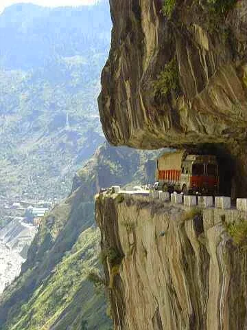
Karnali Highway, Jumla,Nepal.
A riskiest Highway in the world.
Photographer- unknown,
from- facebook ( tagged by Kumar Sapkota )

The
VDC was named after the Hindu goddess, Sundarimai. A temple is dedicated to the deity in Sundarijal.
(
the meaning of sundari = beautiful- speciality female, jal = water)
Sundarijal is a village development
committee in Kathmandu District in the Bagmati Zone of central Nepal.
Sundarijal
is located 15 kilometres (9 mi) northeast of Nepal's capital,Kathmandu.It is west of Gagalphedi, east of Nayapati and Baluwa, and north of Aalapot. The VDC touches Nuwakot and Sindhulpalchok Districts to the north. Sundarijal covers an
area of 5.18 square kilometres (2 sq mi). The Bagmati River flows through the VDC, where it is
joined by the Shyalmati and Nagmati Rivers. Largely hilly in its terrain with
few flat areas, the VDC is covered by forests. Shivapuri National Park covers large amounts of the
Sundarijal.
The climate of Sundarijal is temperate. The average for the
summer is 25.5˚C while that for the winter is 0˚C.
Tourism is a large industry in Sundarijal. Pollution has
risen in the Sundarijal reservoir due to large amounts of tourists who crowd
the VDC every weekend.[4] They
are attracted to the area's natural beauty, including the waterfalls and
rivers. People from Kathmandu valley come due to being about an hour drive
away. In addition, the VDC is a starting point for hikers along the Langtang Range. There are several
picnic tables to meet the needs of tourists.
A 640 kW hydropower plant near the bus park area
provides electricity to Sundarijal. A mail post and police station are also
located here.
There is a US$464 million drinking water project that would bring water from Melamchi, treat it, and distribute it in Sundarijal. A pipeline 58 kilometres
(36 mi) in length would be laid in Sundarijal.
to other places in the Kathmandu Valley.[5] It will start pumping 170 million
liters of water daily in 2011 or 2012.
In
1960, the Sundarijal Military Detention Camp was the location of Nepali
Congress leaders B.P.
Koirala (the
Prime Minister), Ganesh
Man Singh,Krishna Prasad Bhattarai, Diwan Singh Rai, Ram Narayan Mishra, Yogendra Man
Sherchan, and Jaman Singh Gurung. They were held without trial for eight years due
to their participation in a 1960 coup.
There
is a B.P. Koirala museum inside the camp.
Agriculture
in the VDC is only present in the eight ward. No modern technology for this is
in existence, as farmers only use traditional techniques. In the northern part
of the ward, the predominate crops are millet and maize, although cultivation also includes barley and some vegetables. In the southern area, wheat, barley, maize, potato, vegetables and millet are grown.
About
90% of townsfolk can read or write, though less than that number are fully
literate. Members of the younger generation under 25 years of are more likely
to be literate than those over 40 years old.
Sundarijal's
vegetation consists of mostly pine, oak, rhododendron, and other forest types. Wildlife recorded in the
area include theHimalayan Black bear, leopard, jungle
cat, and rhesus
monkey. The area around
Sundarijal is the habitat of 177 species of birds, which includes at least nine
threatened species, 102 species of butterflies with several endangered species,
and 129 species of mushrooms.
- article Wikipedia, the free encyclopedia

Pictures - Google

Photos - Google
A fearless struggle / bravery in Sundarijal for
natural pleasure.
Do you want to relax your mind, heart and body naturally ?
Trapped at the danger zone. So enjoy carefully !
 Picture - Google
A birds eye view from Phulchoki
 Picture - Google
Phulchoki hill
 Picture - Google
Phulchoki Mai
 Picture - Google
The communication tower, Phulchoki
 Picture - Google
A hill scarred by marble quarries opposite of Phulchoki hill
 Picture - Google
An old hollow tree on the way to Phulchoki
 Rajnikunja, Gokarna, Kathmandu,Dakshin Dhoka / Picture B. P.
 Inside Dakshin Dhoka ( South Gate ), Rajnikunja, Gokarna
Picture - B.P. Dhungana
 Rajnikunja, Gokarna ( east gate ) near Dachhee Monastry
Picture - B.P. Dhungana
 Rajnikunja, Gokarna ( east gate ) near Dachhee Monastry

A birds eye view from Phulchoki

Phulchoki hill
Phulchoki means 'flower covered hill' in Nepali.
Phulchoki
is a 2791 meter high hill, located about 20 K.M. south-east of Kathmandu and a
good hiking spot as it offers a spectacular view of the whole Kathmandu Valley.
It is the
tallest hill in the Valley. It is triple-peaked. Rhododendrons of different colours
are found here, including pure white and dark-red varieties. A Jeepable road
leads to the top of the hill, where there is a Buddhist stupa.
- Article The book – Experience it in Nepal ( Nepal Tourism Board )

Phulchoki Mai

The communication tower, Phulchoki

A hill scarred by marble quarries opposite of Phulchoki hill

An old hollow tree on the way to Phulchoki


Picture - B.P. Dhungana

Picture - B.P. Dhungana

Picture - B.P. Dhungana
 Picture - GOOGLE
Gokarna Forest Resort, inside Rajnikunja
http://www.gokarna.com
 Gokarna Golf Club inside Rajnikunja, Gokarna, Kathmandu
Picture - Google
Gokarna

Gokarna Forest Resort, inside Rajnikunja
http://www.gokarna.com

Picture - Google
Gokarna
Gokarna safari park ( Rajnikunja Gokarna ), lies
about ten kilometers north-east of Kathmandu. It is situated on the bank of the
river Bagmati. Wild animals such as the spotted deer are found in the
sanctuary. We could be view from elephant back / horse carriage but nowadays
there is no enterance for public. Only Gokarna Forest Resort is open for
Gokarna Forest Resort customers(public) near Dakshin Dhoka gate (south-east). On the northern side of Gokarna, on the way to Sundarijal, is a pagoda-style
temple of Gokarneshwar Mahadev(an ancient temple). To its right, situated on
a hillock, there is a small ancient village known as Gokarna Gaon.
- Article The book – Experience it in Nepal ( Nepal Tourism Board )
Rajnikunja is called Sauraha of Kathmandu.
There is an army camp inside North part of Rajnikunja, Gokarna.

The ancient Temple of Vajravarahi is situated in
a small woodland Park located about ten kilometers south of Patan, near the village
of Chapagaon. A visit to Tikabhairav and Lele from here is well worthwhile.
- Article The book – Experience it in Nepal ( Nepal Tourism Board )
This place is also a nice picnic spot.

The ancient Temple of Vajravarahi


The Everest base camp Helicopter tour meets the
desires of tourists who want to take the advantage in their short period of
time. Though it is launch for short program, but it will be memorable forever.
It is the fit for each and every type of physical persons.


 Namche Bazar Area, Nepal
Photo: www.fotopedia.com ( Flickr )


Photo: Flickr.com / Google

Photo: Wikipedia, the free encyclopedia
The Annapurna massif, view from aircraft

Photo:Google
Annapurna Base Camp Range

Photo: Google

Photo: Google
Annapurna Area

Photo: Google

Photo: Google
Annapurna region

Annapurna is the 10th highest mountain in the world


The Everest base camp Helicopter tour meets the
desires of tourists who want to take the advantage in their short period of
time. Though it is launch for short program, but it will be memorable forever.
It is the fit for each and every type of physical persons.
Your journey starts from Kathmandu airport with a helicopter moving eastwards, flying parallel to the Himalayan range, allowing magnificent vistas of the soaring Himalayan peaks. After landing at Lukla for fuelling you will fly to the airstrip in Syangboche (12,340ft) or if you wish to have breakfast at Hotel Everest View, the helicopter will land at Hotel’s helipad.
From Syangboche you can have sightseeing helicopter tour closer to Mt. Everest and all the magnificent himalays like Amadablam, Pumori, Number, Cho Oyu (8201m) in the Khumbu region. The Solukhumbu (Solu) region of Nepal where lies the Mt. Everest ( 8,848 m ) has been a magnet for travellers ever since its opening to foreigners in 1950. This region is famous not only for its proximity to the world’s highest mountain but also for its Sherpa villages and monasteries with their virtually unchanged unique culture. Solu has received countless trekkers and mountaineers from all over the world. Solukhumbu has developed to a stage where many options are possible from a full-scale expedition with tents and porters to an independent trek using the local lodges.
- article http://www.trekkingagencynepal.com

1) Photo - http://www.pbs.org 2) Photo - plus.GOOGLE.com / A beautiful view of Everest
Base Camp in the night. 3) Photo - Wikipedia, the free encyclopedia / Tent village established for tourists' convenience called Everest Base Camp in Nepal, in Tibet side. It is the furthest that private cars can go. 4) Photo - www.classicasianholidays.com

A Beautiful scene of Everest Base Camp area, Nepal.

Photo - commons.wikimedia.org
A yellow yak in Everest Base Camp.

Photo-1)Google/peakpromotionnepal.com-Phakding to Namche Bazar 2) Photo - http://tripwow.tripadvisor.com 3) Photo - http://tripadvisornepal.blogspot.com / The National bird of Nepal Monal-pheasant 4) Photo - http://www.nepalindependentguide.com / Tame Dhukur ( A special species of dove ) 5) Photo - http://tripadvisornepal.blogspot.com / The National flower of Nepal - rhododendron

Photo: Google
Ophiocordyceps sinensis ( normal popular name - Yarshagumba )
The Nepali name is yarshagumba, yarchagumba or yarsagumba (Jeevanbuti).
Ophiocordyceps sinensis is
a fungus that parasitizes larvae
of ghost
moths and
produces afruiting body valued
as an herbal
remedy. The fungus germinates in the living
larva, kills and mummifies it, and then the stalk-like fruiting body emerges
from the corpse. It is known in English colloquially as caterpillar fungus, or by its more prominent foreign names (see
below): yartsa gunbu or yatsa gunbu (Tibetan),
or Dōng chóng xià cǎo (Chinese: 冬虫夏草; literally "winter
worm, summer grass") i.e., "worm in
the winter, [turns to] plant in the summer".
The
moths in which O. sinensis grows are ambiguously referred to as
"ghost moth", which identifies either a single
species or
the genus Thitarodes, and the species
parasitized by O. sinensis may be one of several Thitarodes that live on the Tibetan
Plateau (Tibet,
Qinghai, West-Sichuan, SW-Gansu & NW Yunnan), and the Himalayas (India, Nepal, Bhutan).
In rural Tibet, yartsa
gunbu has become the most
important source of cash income. Prices have increased continuously, especially
since the late 1990s. In 2008, one kilogram traded for US$3,000 (lowest
quality) to over US$18,000 (best quality, largest larvae).
- Wikipedia, the free encyclopedia

Photo: Google
Rheum Emodi herb ( Padhmachal - Nepali name ), available in Himalayas Nepal
Everest Base Camp area, Nepal.

Everest Region
1) Photo: school-trek---everest-basecamp-26464 2) Photo: Wikipedia, the free encyclopedia ,
Khumbu ice-fall 3) Photo: nepalhimalayatours.com 4) Photo: Google 5) Lukla Everest Trekking:
Photo Google 6) Everest Monastery, Photo: asianheritagetreks.com
On 29 May 1953, Hillary and Nepalese Sherpa mountaineer Tenzing Norgay became the first climbers to reach the summit of Mount Everest. Here are some links:
Mrs. Junko Tabei is a Japanese mountain-climber who, on May 16 , 1975, became the first woman to reach the summit of Mount Everest. The link Is:

Photo - summitpost.org
MichaelWard with WHMurray duringthe 1951 reconnaissance
expedition which was found the route over the Khumbu
icefall used by the Swiss in
1952 and then the successful 1953 expedition.

Saving Mount Everest Clean-Up Expedition Team Successfully bring over 8 Tons of garbage from Mount Everest and its Trekking Trails. - Saving Mount Everest Clean-Up 2011

Source - Department of Survey, DNPWC / PCP Government of Nepal
&
Department of National Parks and Wildlife Conservation
Babarmahal, Kathmandu / Phone: 977-1-4220912/4220850

Inscriptions-and-Flags-on-the-Lukla-Phakding-Trek-Everest-Base-Camp-Nepal
Photo: blogs.gonomad.com , Travel Tales of Mridula from India

Namche Bazar, Nepal
Photo: blogs.gonomad.com , Travel Tales of Mridula from India

Photo: www.fotopedia.com ( Flickr )

Photo-graph: http://www.nationalgeographicexpeditions.com


winter snowfall at Daman,Makwanpur, Nepal
Photo: www.facebook.com

A View of The Breathtaking Grandeur of Daman, Nepal
Photo: www.facebook.com

Scenic- Daman, Nepal
Photo: www.facebook.com

Daman, Nepal
A Beauty of Nature / Photo: www.facebook.com

Daman, Nepal
Photo: www.facebook.com

Daman, Nepal

A Long-range Telescope / Photo: www.facebook.com

Photo: 1) www.facebook.com 2) Chhito.com 3) tripadvisor.com
A view-tower, Daman, Nepal

Winter Snowfall Around Everest Panorama Resort, Daman
Photo: httpwww.everestpanoramaresort.net

Photo: getyourguide.com
A Cheerful Tourist in Daman, Nepal
Daman/Sim-bhanjyang is specially famous for its winter snowfall.
Daman is a village in the central part of Nepal, located in the district of Makwanpur. It is halfway between Kathmandu and Hetauda at 2320m. It lies eighty kilometers south-west of Kathmandu (at an altitude of 2320 metres) on the mountain highway known as Tribhuvan Rajpath( Tribhuvan Highway ). For a view of the breathtaking grandeur of the
world’s highest peaks from the far west of Dhaulagiri to the east of Mount
Everest ( Sagarmatha ), there is no better
place than Daman.
The village also contains a resort - Everest Panorama Resort, which also has a helipad (view tower) fitted with a
long-range telescope in its premises. Since the village lies in the outskirt of Kathmandu, it provides a great opportunity for the people residing in Kathmandu to observe its beauty and use for means of recreation.
- sources of this article Wikipedia, the free encyclopedia
&
The book – Experience it in Nepal ( Nepal Tourism Board )
 Lambagar, Dolakha, Nepal
Photographer- unknown
From- facebook ( tagged by Sabeena Karki )


 Kodari is a border crossing on the Nepal-China border. It s located in Sindhupalchok District in the Bagmati Zone of central Nepal. The other side of the border is variously referred to as Zhangmu, Dram or Khasa.

Photographer- unknown
From- facebook ( tagged by Sabeena Karki )


Kodari is located at an altitude of 2,515 metres (8,251 ft). Kodari is 114 kilometres (71 mi) from Kathmandu. The height gain is from 1,317 metres (4,321 ft) to 2,300 metres (7,500 ft). On a clear day, the Himalayan chain is visible on both sides of the road. From Zhangmu to Nyalam, a distance of 33 kilometres (21 mi) the height gain is from 2,300 metres (7,500 ft) to 3,750 metres (12,300 ft).
China built the 115 kilometres (71 mi) Kathmandu-Kodari Road, since named Araniko Highway, during the 1963-67 period. As of 2011, Nepal is planning to convert the two lane highway to a six lane metalled highway. It connects across the Nepal Friendship Bridge (Miteri Pul) at the border to Friendshp Highway in the Tibet Autonomous Region of China.
In ancient times, it was the starting point of a trans-Himalayan caravan route. Newar traders headed north from Kodari and after crossing Kuti pass turned east to continue their journey across the Tibetan Plateau to Lhasa.
China started building a railway in 2008 connecting Lhasa with Zhangmu on the Nepal-China border. It is an extension of the 1,956 kilometres (1,215 mi) Qinghai-Tibet Railway.
Sindhupalchok District is a part of Bagmati Zone and one of the seventy-five districts of Nepal, with an area of 2,542 km2 (981 sq mi). The district's headquarters is in Chautara. In 2006, 336,478 people resided in 79 village development committees, in 2011 there were 287,798.
This district is close to Nepal's capital Kathmandu, it is one of the least developed districts in Nepal. The Arniko Highway, also called Kodari Highway, (114 km) extending from Kathmandu to Kodari links this district with Tibet. The district is mountainous and rich in natural resources.
The district is easily accessible from Kathmandu, but is not well developed. People depend entirely on agriculture for their survival. Since the district is hilly, the land is not very fertile land, and the yield is very low. So, the lifestyle of people is not easy. Almost every VDC has got electrical power and roads connecting to the nearby highway. Many NGOs and INGOs are working in the district in order to improve the living standards.
Rivers like Bhotekoshi, Indrawati, Sunkoshi and Bramhayani (Balephi) flow through this district. The major towns are Chautara, [MIdle rigen Gaurati Bhimeswar Mandir Near Syaule VDC My village Settlement Bhedabari] Barhabise, Melamchi, Jalbire and Tatopani. Sunkoshi Hydropower station and Upper Bhotekoshi Hydropower station are popular hydropower stations connected to national grid. Meanwhile, many mini and large hydroelectricity projects are being constructed in different places. Two FM radio stations also operate from Melchaur and Barhabise.
Although one of the least developed, this district can be one of the finest tourist destination attracting both national and international tourists.
Cultural heritages like Gaurati Bhimeshwor temple, Tauthali Mai Temple, Sunkoshi Kafeshwor Mahadev Temple, Kshemadevi Temple, Larke Ghyang are the popular pilgrimages in the district. Sunkoshi and Bhotekoshi are the world famous rafting rivers which are flowing via this district. Bhairav Kundaand Panch Pokhari are popular trekking destination which has religious and cultural important. Bungy Jump over the Bhote Koshi river is another attraction of Sindhupalchok. Tatopani (Hot Water Spring) near by Nepal China boarder is popular as pilgrimage place. Besides these, there are so many attraction that are still behind the flash. Hill stations like Tamche, Ghunde, Yangima Danda has high probability for tourism.
The tourist places of this district include Langtang National Park, Langtang Himal, Jugal Himal, Panch Pokhari, Tato pani, and Gaurati Bhimeswor. Yearly, thousands of tourists visit Ultimate Bunjee at The Last Resort, the longest freefall in the world(500 ft) into Bhotekoshi river. It is located at 100 km from Kathmandu near Araniko highway and just 12 km from China border.
- sources of this article Wikipedia, the free encyclopedia


Photo: Facebook.com
Tatopani ( hotwater spring ) Myagdi, Singha, Nepal

Photo: hotsoaksofthehimalaya.blogspot.com
Tatopani ( hotwater spring ) Myagdi, Singha, Nepal

Photo: Facebook.com
Tatopani ( hotwater spring ) Myagdi, Singha, Nepal

Photo: Facebook.com
Tatopani ( hotwater spring ) Myagdi, Singha, Nepal
Myagdi district is one of the most popular
destination for Tourism. The world famous Poon Hill lies in the Shikha VDC of
this district. Ghorepani is the another attraction for travelers. The
trekking/hiking trail Ghorepani Poon Hill Trek is considered as easy and most liked trail in Annapurna
region. The flora and fauna of this district is unique. Not only in natural
resources, it is rich in cultural heritage.
Myagdi District(Nepali: म्याग्दी जिल्ला), a part of Dhaulagiri Zone,
is one of the seventy-five districts of Nepal, a landlocked country of South Asia.
The district, with Beni as its district headquarters, covers an area of
2,297 km², had a population of 114,447 in 2001 and 113,641 in 2011.
- sources of this article Wikipedia, the free encyclopedia


Photo: letstournepal.com
Above-Bandipur village,Nepal, A birds eye view

Photo: www.responsibletreks.com
Scenic-Bandipur, Nepal

Photo: www.redcarpet.com.np
A delightful rural scene, Bandipur-Pokhara

Photo: breatheoutbreatheindia.wordpress.com
A natural hut in Bandipur


Photo: www.namastetanahun.com
Siddha Gupha, Tanahun, Bandipur, Nepal

Photo: beinspiredby.blogspot.com

Photo: YouTube.com
Tourist Attraction in Bandipur, Nepal
Bandipur (Devanagiri बन्दीपुर) is a hilltop settlement in Tanahu District, (Gandaki Zone) of Nepal. Because of its preserved, old time cultural atmosphere.
Bandipur is located at 27.56 N, 84.25 E and an elevation of 1030m on a mountain saddle (Mahabharat range) approximately 700m above the Marsyangdi River Valley, 143 km to the west ofKathmandu and 80 km to the east of Pokhara. Since 1998 it is connected by a 8 km access road from Dumre (Kathmandu-Pokhara highway). Until then there was only an unreliable road, in monsoon usually not accessible or only by tractors. The mountain saddle, just 200m long, is barely wide enough to accommodate the main street lined by 2 –3 storey buildings on either side.
Bandipur was established as a funnelling point of trade by Newar traders from Bhaktapur in the Kathmandu valley after it had been conquered in 1768 byPrithvi Narayan Shah. They took advantage of its malaria free location to develop it into an important stop along the India-Tibet trade route. With them they brought their cultural heritage and architecture which basically has remained unchanged to this day.
Originally a simple Magar village in the early 19th. Century Bandipur developed into prosperous trading centre and a community with town-like features: substantial buildings, with their neoclassical façades and shuttered windows and streets paved with slabs of silverish slate. Bandipur had its heyday in theRana times (1846-1951), when, as a measure of its power and prestige, it was granted special permission to have its own library (still existing).
A
terrific excursion here are the Bandipur Caves which attract both devout
pilgrims and adventurers. One of the country’s largest and most accessible
caves, these limestone formations have religious and imaginative significance.
- main sources of this article Wikipedia, the free encyclopedia


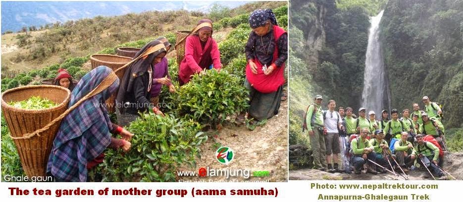
Visitors to Ghalegaun-Ghanpokhara are welcomed with offering of garlands and tika while music and dances are performed and traditional farewell songs are sung when guests depart. Nepali New Year and Buddha Jayanti are celebrated with traditional dance called Ghatu. The people of Ghalegaun-Ghanpokhara keep goats and sheep and use wool from these animals to make woolen products. They make clothes and bags from nettle fiber (allo cloth) and scarfs, towels and shawls from the wool of angora rabbits. Ironsmiths make different iron products. Craftsmen produce a whole range of different products from bamboo.
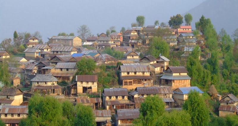
Photo: www.adventuremilestone.com
Ghalegaun, Lamjung, Nepal
Photo: www.nepalhomepage.com
Ghalegaun, Lamjung, Nepal
Gurung people (Ghales) and their traditional dance.


Ghalegaun situated at the foot of Lamjung Himal in north
central Nepal. Ghanapokhara is a beautiful village heading towards
development with a concept of eco-tourism. It lies at north of Lamjung district.
Ghalegaun
-Ghanpokhara are model villages for experiencing the typical culture and
lifestyle of the Gurung people (Ghales). Traditional customs are still followed
during births, deaths, marriages and at other important times in a person`s
life. Age-old cultural dances like the Jhyaure, Serka, Dohori, GhantuGhyabring,
Krishna Charitra and Jhakri are performed on various occasions accompanied by
different musical instruments with the dancers in traditional dress.
Visitors to Ghalegaun-Ghanpokhara are welcomed with offering of garlands and tika while music and dances are performed and traditional farewell songs are sung when guests depart. Nepali New Year and Buddha Jayanti are celebrated with traditional dance called Ghatu. The people of Ghalegaun-Ghanpokhara keep goats and sheep and use wool from these animals to make woolen products. They make clothes and bags from nettle fiber (allo cloth) and scarfs, towels and shawls from the wool of angora rabbits. Ironsmiths make different iron products. Craftsmen produce a whole range of different products from bamboo.
The approach to Ghalegaun-Ghanpokhara is a wonderful
experience in itself as it goes crossing over the Marsyandi, Khudi and Midim
rivers; passing through rhododendrons blossoming along the way amidst the
chirping of birds and wild insects. The trekking route passes through dense
jungle and villages and impressive waterfalls. Nearby Talyngo Lake and Lami
Lake add new dimension to these attractions. Activities around this village
including bird watching at Talangyo lake, and visitors to the Utter Kanya
temple, Pempro fall, Batase cave and the Khudi hydroelectric dam-site.
Ghalegaun
and Ghanpokhara are mainly Gurung settlements; they nestle amidst mountains,
rivers, streams, waterfalls and green forests. These places command a superb
breathtaking view of majestic western Himalayas including Machhapuchhare(6693m)
Annapurna (8091m), Annapurna II (7939m) Annapurna IV (7525m), Lamjung Himal,
Bouddha Himal(6974m), Himalchuli (6747m) and many more smaller peaks.
- Main sources of this article: http://www.nepaltourismdirectory.com


